Joining Data
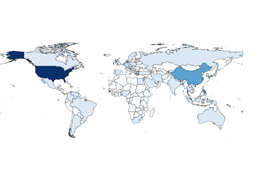
Joining multiple datasets on a common value or set of values is a common data wrangling task. For instance, one might have a dataset listing Gross Domestic Product (GDP) per country and a separate dataset containing geographic outlines of country borders. If these independent datasets have a shared property (for instance, the three-letter country code as defined in ISO 3166-1 (opens new window)),we should be able to create one consolidated dataset to generate a map of GDP per country. This guide will walk through this simple use case.
# Example Data
For this example, we are going to use two example Data Packages from our example data packages repository (opens new window) with the properties described above. The first is an example of Data Package containing a GeoJSON file. GeoJSON (opens new window) is a format for representing geographical features in JSON (opens new window). This particular GeoJSON file lists countries on its features array and specifies the country code as a property on each “feature”. In this case, the country code is stored on the key “ISO_A3” of the feature’s properties object.
{
  "type": "FeatureCollection",
  "features": [
    {
      "type": "Feature",
      "properties": {
        "ADMIN": "Ukraine",
        "ISO_A3": "UKR"
      },
      "geometry": {
        "type": "Polygon",
        "coordinates": [
        "..."
        ]
      }
    }
  ]
}
The second Data Package is a typical Tabular Data Package (opens new window) containing a GDP measure for each country in the world for the year 2014. Country codes are stored, naturally, on the “Country Code” column.
| Country Name | Country Code | Year | Value |
|---|---|---|---|
| Ukraine | UKR | 2014 | 131805126738.287 |
| United Arab Emirates | ARE | 2014 | 401646583173.427 |
| United Kingdom | GBR | 2014 | 2941885537461.48 |
| United States | USA | 2014 | 17419000000000 |
| Uruguay | URY | 2014 | 57471277325.1312 |
# Reading and Joining Data
As in our Using Data Packages in Python guide, the first step before joining is to read the data for each Data Package onto our computer. We do this by importing the datapackage library and passing the Data Package url to its DataPackage method. We are also importing the standard Python json library to read and write our GeoJSON file.
import json
import datapackage
countries_url = 'https://raw.githubusercontent.com/frictionlessdata/example-data-packages/master/geo-countries/datapackage.json'
gdp_url = 'https://raw.githubusercontent.com/frictionlessdata/example-data-packages/master/gross-domestic-product-2014/datapackage.json'
countries_dp = datapackage.Package(countries_url)
gdp_dp = datapackage.Package(gdp_url)
world = json.loads(countries_dp.get_resource('countries').raw_read().decode('UTF-8'))
Learn more about creating data packages in Python in this tutorial.
Our GeoJSON data is stored as a bytes object in the data attribute of the first (and only) element of the Data Package resources array. To create our world GeoJSON dict, we first need to decode this bytes object to a UTF-8 string and pass it to json.loads.
world = json.loads(countries_dp.get_resource('countries').raw_read().decode('UTF-8'))
At this point, joining the data can be accomplished by iterating through each country in the world['features'] array and adding a property “GDP (2014)” if “Country Code” on the gdp_dp Data Package object matches “ISO_A3” on the given GeoJSON feature. The value of “GDP (2014)” is derived from the “Value” column on the gdp_dp Data Package object.
for feature in world['features']:
    matches = [gdp['Value'] for gdp in gdp_dp.resources[0].data if gdp['Country Code'] == feature['properties']['ISO_A3']]
    if matches:
        feature['properties']['GDP (2014)'] = float(matches[0])
    else:
        feature['properties']['GDP (2014)'] = 0
Finally, we can output our consolidated GeoJSON dataset into a new file called “world_gdp_2014.geojson” using json.dump and create a new Data Package container for it. For a more thorough walkthrough on creating a Data Package, please consult the
Creating Data Packages in Python guide.
new_dp = datapackage.Package()
new_dp.descriptor['name'] = 'consolidated-dataset'
new_dp.descriptor['resources'] = [
  {
    'name': 'data',
    'path': 'world_gdp_2014.geojson'
  }
]
new_dp.commit()
new_dp.save('datapackage.zip')
We can now quickly render this GeoJSON file into a chloropleth map (opens new window) using QGIS (opens new window):

Or we can rely on GitHub to render our GeoJSON for us. When you click a country, it’s property list will show up featuring “ADMIN”, “ISO_A3”, and the newly added “GDP (2014)” property.


